Below is a list and summary of the unconstructed state highways in the U.S. state of Arizona. Some are currently proposed while the others have been since cancelled prior to being constructed.
Contents |
State Route 24 (formerly designated as State Route 802), also known as the Williams Gateway Freeway, is a planned freeway in the extreme southeastern region of the Phoenix Metropolitan Area. It will start at Loop 202 Santan Freeway near the Phoenix-Mesa Gateway Airport and its eastern terminus will eventually be either at US 60 southeast of Gold Canyon or SR 79 south of Florence Junction. It is planned as a controlled-access freeway to move traffic from the eastern suburbs of Phoenix to planned ones in western Pinal County.
State Route 30 (formerly designated as State Route 801), also known as the I-10 Reliever, is a planned state highway in the southwest parts of Phoenix, Arizona and nearby suburbs. It will connect the southern terminus of Loop 303 with the South Mountain leg of Loop 202. It is planned as a controlled-access freeway to relieve heavy traffic congestion experienced along Interstate 10 in the area.
State Route 48 is a proposed short highway running roughly northwest to southeast between State Route 89A and State Route 69 in Prescott Valley, Arizona. It is primarily intended as an eastern bypass around Prescott. The road is currently two lanes but there are plans to widen it to a divided 4 lane highway. It hasn't been added to the state highway system. From 1939-1945 Fain Road was the old road for State Route 179.[1] There are some maps that still show Fain Rd as SR 179, but that is incorrect since the route number is already used as the main road to Sedona.
State Route 50, also known as the Paradise Parkway, was a proposed urban freeway in Phoenix and Glendale. Originally proposed in the 1980s, the freeway would have run east to west, connecting State Route 51 and Loop 101, roughly parallel to and 4 miles (6.4 km) north of I-10, in the vicinity of Camelback Rd. As the proposed freeway would have crossed through largely developed land and densely populated neighborhoods, it proved to be both extremely expensive and highly unpopular. The route was eventually struck from state planning maps and all land acquired for right-of-way was subsequently sold, the funds being used to pay for other transportation projects.
State Route 76 was a proposed state highway in eastern central Arizona, United States that would have connected State Route 77 and San Manuel. There was a planned extension to Benson which would have been State Route 176. It was shown on state maps in the 1970s but was never built. It would have followed the San Pedro River on its entire length.
| ← SR 75 | SR 77 → | |
State Route 176 was a proposed state highway in eastern central Arizona, that would have connected Benson and San Manuel before reaching State Route 77. It was shown on state maps in the 1970s but was never built. It would have followed the San Pedro River on its entire length.
| ← SR 173 | SR 177 → | |
State Route 380 was a proposed state route that was never constructed in the eastern part of the state of Arizona. It was proposed, starting in the town of St. Johns and would have ended at the New Mexico state line. It shows up on some state maps during the 1970s, but was never built. The road proposed is currently a dirt ranch road. In St. John's, it would have begun at a junction with U.S. Route 180, a child of U.S. Route 80.
| ← SR 377 | SR 386 → | |
State Route 487 was a proposed state route that was never constructed in the north-central part of Arizona. Arizona Department of Transportation was considering adding it to the state highway system in the early 1970s between Flagstaff and State Route 87 near Happy Jack. It did show on state maps during the early 1970s but was never added to the state system and the route disappeared in the mid to late '70s. The road currently exists today as National Forest Road Route 3.
| ← SR 473 | SR 504 → | |
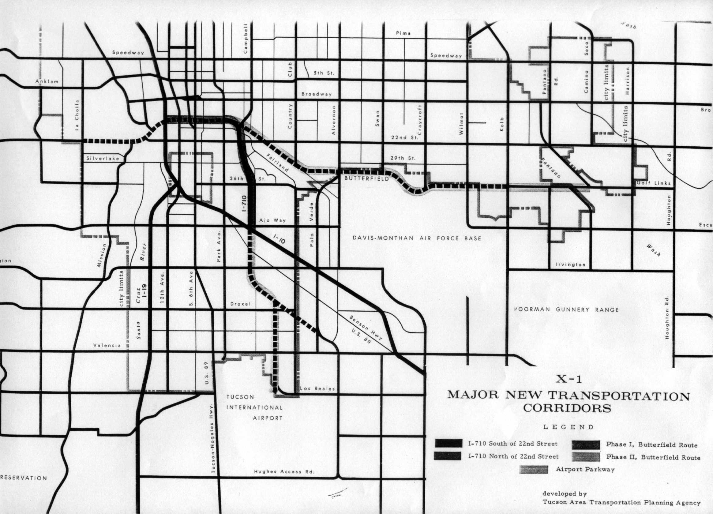
I-710 was proposed to follow the current day alignment of Kino Parkway, an at-grade parkway, between Broadway Rd and Interstate 10 in Tucson, Arizona. But it was never built. This freeway, if built, would have served the Downtown area, the University of Arizona campus and the industrial area between the railroad and I-10; an extension to Tucson International Airport was also proposed. [1], and also first shown on a Tucson map in 1971. Strong community opposition to freeways in Tucson was a major reason for cancellation of the project; the Tucson area has long been opposed to the rapid urban sprawl since. [2]
|
||||||||